Overview & Applicability
The Forest Planner enables landowners in Oregon and Washington to find, map, and design custom forest management scenarios for their properties. Users can select the property and forest stands that they want to examine, enter information about the tree species and forest types represented, and select from a variety of management scenarios. The Forest Planner then shows side-by-side graphs and maps that compare management outcomes for a variety of variables, including timber stocking and yields, harvest costs and revenues, carbon storage, fire and pest hazard ratings.
The values for each of these variables are approximations based on the modeling of similar forest inventory plots. Forest Planner produces these estimates by comparing user-selected properties with forest inventory data for plots that are similar in forest type and geography, and using these comparison plots in their model. The developers therefore advise using the Forest Planner to compare different management scenarios rather than focusing on the specific outputs for any single year or management scenario. Estimated outputs do NOT account for projected changes in climate.
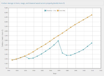
 A chart from the Forest Planner comparing forest carbon storage estimates for two different management scenarios.
History
Forest Planner was developed from 2011-2013 by Ecotrust, and published online in March 2014 following beta-testing with non-industrial private forest owners around Oregon and Washington.
Inputs and Outputs
Inputs
Users are guided through several selections for their property of interest. In addition to selecting the property boundaries and forest stands on a map interface, users select:
- The forest types associated with their property by selecting tree species, diameter range, approximate number of trees per acre, and stand age.
- One or more management scenarios to compare, ranging from a default ‘grow only’ scenario to several silvicultural prescriptions.
Outputs
Graphs and maps of several variables through the year 2120, including:
- Carbon storage, standing and harvested timber volumes (boardfoot volume, cubic volume, boardfoot yield, etc.)
- Spruce beetle hazard, pine beetle hazard, wildfire hazard.
- Harvest cost and revenues.
Although graphs estimate these variables through approximately 2120, it is important to note that future climate changes are NOT included in this model. Climate change could have a large effect on carbon stores and other modeled variables.
Restrictions and limitations
- As noted above, climate scenarios are not yet included in Forest Planner, and so future estimates of carbon values and other variables, which are partially dependent on climate change effects and disturbance, must be interpreted with this in mind.
- The values you see in maps and graphs are approximations for a property based on modeling of similar forest inventory plots; they do not show the values that would be returned if your own inventory data was modeled.
- In general, Forest Planner encourages users to visualize trends and outcomes comparing different management scenarios rather than focusing on the specific outputs for any single year or management scenario. This information may be helpful for evaluating different management alternatives and for management planning purposes, but should not be considered as an operations plan.
- Using the Forest Planner is not a substitute for consulting with a qualified forester. Before implementing any management activities on your property, Forest Planner strongly encourages you to develop a sustainable forest management plan in consultation with a qualified forester.
More documentation of modeling assumptions, growth-and-yield environment, etc. are available at http://forestplanner.ecotrust.org/trees/documentation
Accessing the tool and additional information
Home page: http://forestplanner.ecotrust.org/
An introductory video with overview of Forest Planner as well as four screencasts of how the tool works are available at: https://vimeo.com/album/2999692

