
Overview & Applicability
 The California Avian Data Center is using climate models and multi-source bird data, networked for the first time thanks to the Avian Knowledge Network, to predict current and future species distributions for California terrestrial breeding bird species. Currently, they have nearly 200 species available for viewing. These species represent 7 major habitat types found within California including riparian, oak woodland, scrub, conifer, grassland, wetlands, and desert habitat types.
The California Avian Data Center can be used to model either bird distribution, vegetation, or climate in the 7 major habitat types. Users can choose between the GFDL CM2.1 and the NCAR CCSM3.0 climate models.
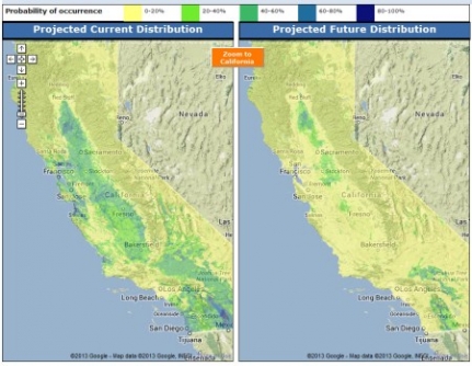
The end product is a map with current distribution and an additional map with projected future distribution.
It is important to remember that models, however sophisticated, are simplifications of reality. Due to various sources of uncertainty in climate models and species distribution models, climate change projections will differ depending on which combination of models is selected. Each projection may be viewed as a plausible future scenario; areas where multiple models agree can be interpreted with greater confidence.
History
Models were developed using presence information from a compilation of different bird survey datasets from PRBO Conservation Science, the Redwood Sciences Laboratory (RSL), Klamath Bird Observatory (KBO), The California Natural Diversity Database (CNDDB) and USGS Breeding Bird Survey (BBS), and eBird. The combination of these datasets is made possible by the California Avian Data Center (CADC) a node of the Avian Knowledge Network (AKN). Each of these sources have a high spatial accuracy, collectively covering all major geographical regions of the state. Bird data were filtered to remove non-breeding records.Current climate data were based on monthly climate means for the years 1971-2000 taken from the PRISM dataset (Daly et al. 1994) and transformed into standard bioclimatic variables (Nix 1986). Future climate scenarios were based on projections from 30-km resolution regional climate models (Snyder and Sloan 2005, Pal et al. 2007) driven by one of two global climate models: 1) NCAR CCSM3.0: National Center for Atmospheric Research Community Climate System Model, averaged for the years 2038-2069 (478-610 ppm CO2); 2) GFDL CM2.1: Geophysical Fluid Dynamics Laboratory Coupled Climate Model, averaged for the years 2038-2070 (478-615 ppm CO2).
Vegetation, soil, and stream data consisted of land cover data from the California Gap Analysis project (Davis et al. 1998), modified SSURGO soil attributes (Miller and White 1998), and streams from the National Hydrography Dataset. Final input variables (Table 1) were chosen based on their predictive abilities and biological relevance.
Inputs & outputs
The user must decide between modeling bird distribution, vegetation, and climate. For modeling bird distribution- The user can decide what habitat type to use
- The user decides what bird species to model
- The user decides on the climate model
- The user decides the climate model
- The user chooses the climate variable