
Overview & Applicability
 This site explores the relationship between plants and climate across Canada. One portion of the site is dedicated to plant hardiness zone maps, which have traditionally been used by gardeners to help select which plant species to grow in their area. Another part of the site presents maps and models that summarize the climatic requirements of thousands of plants from across North America. A final aspect of the site gathers data and provides summaries about plants that occur in your area.
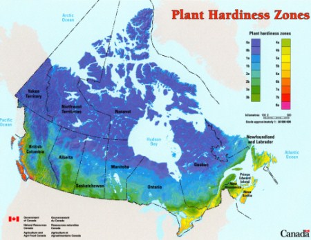
The site includes a Canada Plant Hardiness Zone map and an Extreme Minimum Temperature Zone map based off of USDA extreme minimum temperature zones. There are species specific maps and models using either the ANUCLIM or MaxEnt statistical methods. Users are able to explore plant species in a specified area of interest. Additionally, users are able to enter data for plants in a specified area of interest.
Inputs & outputs
The hardiness zone and extreme minimum temperature maps are easily accessed on the web browser, downloaded as a page size pdf, or a poster sized pdf.To access species specific maps, the user only needs to provide the common or scientific name of their species of interest. The results of this search provide:
- Plant description
- The option to add data
- Map for gardeners
- Current distribution map
- Climate change models
- Bioclimatic profile of the species
- A list of species present in the specified area
- A list of observations submitted in the area